


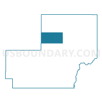
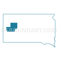
VTD-precinct 29 - Fairpoint, Meade County, South Dakota
About
Outline

Summary
| Unique Area Identifier | 667545 |
| Name | VTD-precinct 29 - Fairpoint |
| County | Meade County |
| State | South Dakota |
| Area (square miles) | 160.25 |
| Land Area (square miles) | 159.84 |
| Water Area (square miles) | 0.42 |
| % of Land Area | 99.74 |
| % of Water Area | 0.26 |
| Latitude of the Internal Point | 44.77623440 |
| Longtitude of the Internal Point | -102.76428480 |
Maps

Graphs
Select a template below for downloading or customizing gragh for VTD-precinct 29 - Fairpoint, Meade County, South Dakota


Neighbors
Neighoring Voting District (by Name) Neighboring Voting District on the Map
- VTD - precinct 14 - Newell Ind, Butte County, SD
- VTD - precinct 8 Union, Butte County, SD
- VTD-precinct 27 - ChalkButte, Meade County, SD
- VTD-precinct 30 - RedOwl, Meade County, SD
- VTD-precinct 33 - Pine, Meade County, SD
- VTD-precinct 35 - Sulphur, Meade County, SD
Top 10 Neighboring County Subdivision (by Population) Neighboring County Subdivision on the Map
- Belle Fourche-Cheyenne Valleys UT, Meade County, SD (1,839)
- East Butte UT, Butte County, SD (788)
- North Meade UT, Meade County, SD (418)
- Union township, Butte County, SD (23)
- Upper Red Owl township, Meade County, SD (22)